|
|
Area |
|
|
Area |
The majority of mid and high altitude air traffic in Canada is controlled from 7 area control centers. The seven ACCs are as follows:
|
Mid and high level airspace within each of the centers "FIR" or Flight Information Region is divided into geographical zones. Each zone has specific ATC communications facilities associated with it. Any one geographic region and block of airspace is referred to as a "sector". Each sector handles a different block of airspace, sometimes 2000 to 5000 feet for a mid-level area to a block starting at 18,000 feet all the way up to 43,000 feet and beyond for a high level control zone.
ATC Sectors
|
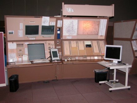
A sector, sometimes also referred to as a specialty, is usually comprised of a radar position and data board position. The controller working the radar communicates with pilots via either local or remotely located transmitters and receivers. Adjacent controllers and facilities can be contacted via landline circuits called "hotlines". The second position at each sector as mentioned is the "data board". You may have seen this depicted in movies or on TV where one controller is sitting in front of a radar display and beside him/her is another controller writing on flight progress strips. These flight progress strips contain computer generated flight plan information telling the controller for that sector the aircraft's type, destination and routing plus other flight information such as requested or assigned altitude for that leg of the flight. Each sector that any flight will progress through will be sent a progress strip for the flight minutes before the aircraft appears on the display "scope". The data board is arranged with active traffic (that which is being controlled by that sector at the moment) and traffic which has not yet been handed over. This provides the controller with a reference of what order aircraft will appear. Every data board has a group of telephone type circuits called "interphones" that can call other data boards in the same ACC or to other facilities and centers allowing flight plan updates to be passed between one another. |
Radar Console and Data Board at the YYZ ACC |
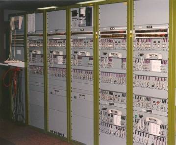
Control equipment for remote transmitters/receivers - (YYZ) |
Each
of the 7 ACCs in Canada cover vast geographical areas, controllers often
work aircraft that are hundreds of miles from the actual control centre
and well out of local radio range. In order to communicate with
flights at those distances remote radio transmitters & receivers are used.
These transmitters and receivers are linked to their respective facility
by either land line or microwave relay. These remote sites, often
referred to as "PALS", extend the radio coverage for each ACC without
requiring staffed facilities in remote regions. |
One of the most important pieces of equipment in aviation today is RAdio Detection And Ranging more commonly known as "Radar". With this technology air traffic controllers are able to visually monitor a flight's progress. Vital information is interrogated from the radar antenna and transferred to the screen for visual presentation. As well as providing navigational assistance, radar is also use in detection of severe weather conditions ( known as X-band, and Doppler radar). At present there are two different types of radar systems in use throughout Canada, Primary Surveillance Radar (PSR) and Secondary Surveillance Radar (SSR). PSR determines the position of aircraft by measuring and displaying radio frequency signals reflected from the aircraft and does not rely on information transmitted from the aircraft. SSR relies on measurement of the time interval between the interrogation and reply by an airborne "transponder" to determine aircraft range. SSR offers significant operational advantages to ATC such as increased range, positive identification, and aircraft altitude when the aircraft is equipped with an altitude encoding transponder. Some years ago Canadian radar systems were revamped under a project known as "RAMP" or Radar Modernization Program. This program was designed to replace older radar systems that used vacuum tube technology with modern advanced computer age technology. RAMP incorporates 42 state of the art radar systems which utilize solid state computer technology allowing considerable data processing at the radar site. These systems provide more accurate information in regards to aircraft position. The coverage of these systems borders on the United States and continues north for 500 kilometers and some 250 nautical miles out to sea.
|
|
|
|
PAR is a high definition short range primary surveillance radar used as an approach aid. This system provides controllers with altitude, azimuth, and range information of high accuracy to assist pilots in executing approaches. While this is basically a military system, PAR is available at some civilian airports.
Radar surveillance of surface traffic is provided at certain airports where traffic warrants. This high definition primary radar is used by tower controllers to monitor the position of aircraft and vehicles on the runways and taxiways, particularly during conditions of reduced visibility.
Introduction | Local Area Control | Arrivals | Departures | FSS | ATC Transcript